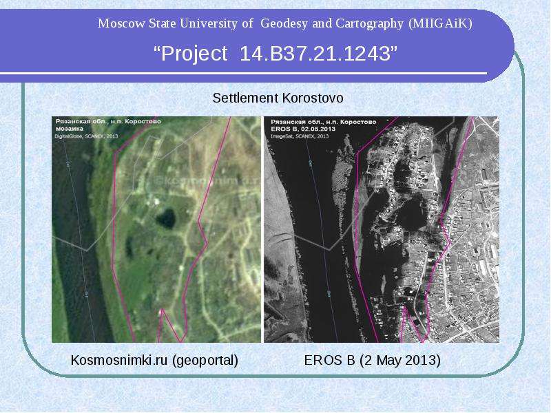
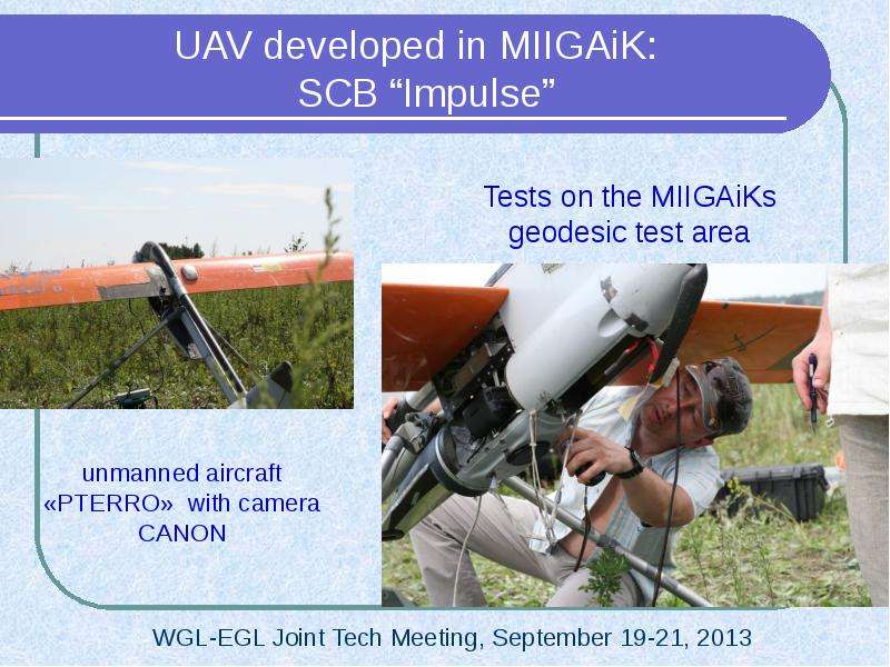
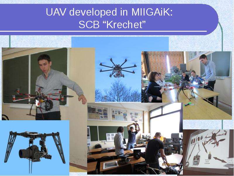
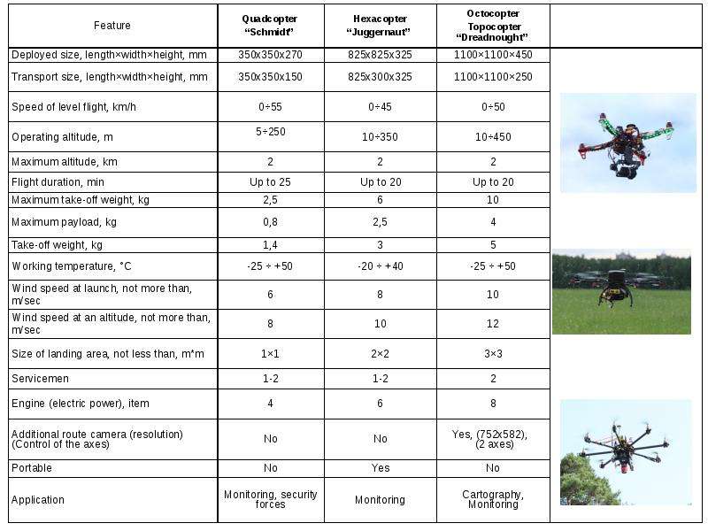
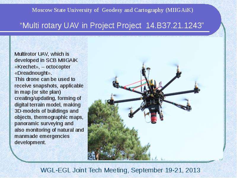
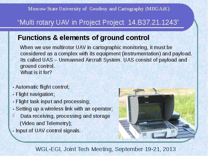
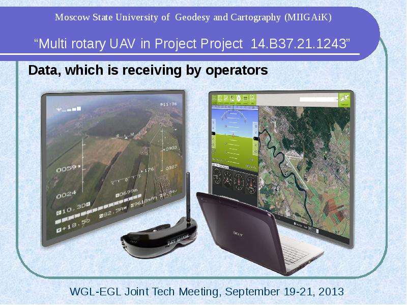
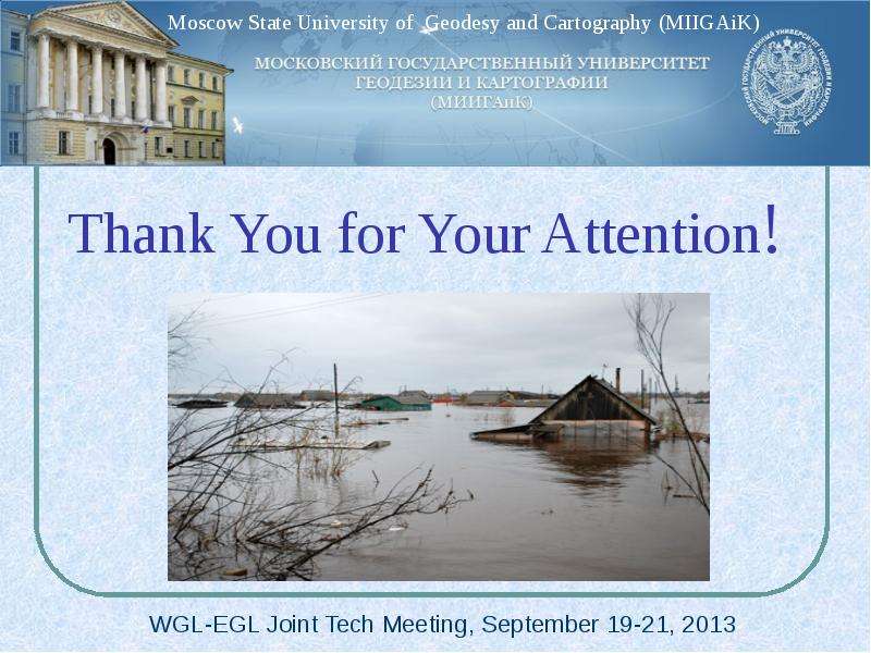
🗊GIS - презентация к уроку Технологии_

Категория: Технологии
Нажмите для полного просмотра!
GIS - презентация к уроку Технологии_, слайд №1GIS - презентация к уроку Технологии_, слайд №2GIS - презентация к уроку Технологии_, слайд №3GIS - презентация к уроку Технологии_, слайд №4GIS - презентация к уроку Технологии_, слайд №5GIS - презентация к уроку Технологии_, слайд №6GIS - презентация к уроку Технологии_, слайд №7GIS - презентация к уроку Технологии_, слайд №8GIS - презентация к уроку Технологии_, слайд №9GIS - презентация к уроку Технологии_, слайд №10GIS - презентация к уроку Технологии_, слайд №11GIS - презентация к уроку Технологии_, слайд №12GIS - презентация к уроку Технологии_, слайд №13GIS - презентация к уроку Технологии_, слайд №14GIS - презентация к уроку Технологии_, слайд №15GIS - презентация к уроку Технологии_, слайд №16GIS - презентация к уроку Технологии_, слайд №17GIS - презентация к уроку Технологии_, слайд №18GIS - презентация к уроку Технологии_, слайд №19GIS - презентация к уроку Технологии_, слайд №20GIS - презентация к уроку Технологии_, слайд №21GIS - презентация к уроку Технологии_, слайд №22GIS - презентация к уроку Технологии_, слайд №23GIS - презентация к уроку Технологии_, слайд №24GIS - презентация к уроку Технологии_, слайд №25GIS - презентация к уроку Технологии_, слайд №26GIS - презентация к уроку Технологии_, слайд №27GIS - презентация к уроку Технологии_, слайд №28GIS - презентация к уроку Технологии_, слайд №29GIS - презентация к уроку Технологии_, слайд №30

Вы можете ознакомиться и скачать GIS - презентация к уроку Технологии_. Презентация содержит 30 слайдов. Презентации для любого класса можно скачать бесплатно. Если материал и наш сайт презентаций Вам понравились – поделитесь им с друзьями с помощью социальных кнопок и добавьте в закладки в своем браузере.

Слайды и текст этой презентации


Слайд 1


GIS - презентация к уроку Технологии_, слайд №1
Описание слайда:

Слайд 2


GIS - презентация к уроку Технологии_, слайд №2
Описание слайда:

Слайд 3


Funding: the study was supported by The Ministry of education and science of the Russian Federation. 
The project is implemented under the guidance of the invited foreign scientist
The project involves three PhD, 6 PhD students and 6 students from MIIGAiK
Using space and UAVs remote sensing data in emergency situations
Using open source technologies for making Emergency web-portal
Creating multimedia educational online content
Описание слайда:
Funding: the study was supported by The Ministry of education and science of the Russian Federation. Funding: the study was supported by The Ministry of education and science of the Russian Federation. The project is implemented under the guidance of the invited foreign scientist The project involves three PhD, 6 PhD students and 6 students from MIIGAiK Using space and UAVs remote sensing data in emergency situations Using open source technologies for making Emergency web-portal Creating multimedia educational online content

Слайд 4


Town Alatyr, Chuvashia region
Описание слайда:
Town Alatyr, Chuvashia region Town Alatyr, Chuvashia region

Слайд 5


GIS - презентация к уроку Технологии_, слайд №5
Описание слайда:

Слайд 6


GIS - презентация к уроку Технологии_, слайд №6
Описание слайда:

Слайд 7


GIS - презентация к уроку Технологии_, слайд №7
Описание слайда:

Слайд 8


UAV developed in MIIGAiK:  
SCB “Impulse”
Описание слайда:
UAV developed in MIIGAiK: SCB “Impulse”

Слайд 9


UAV developed in MIIGAiK:  
SCB “Krechet”
Описание слайда:
UAV developed in MIIGAiK: SCB “Krechet”

Слайд 10


GIS - презентация к уроку Технологии_, слайд №10
Описание слайда:

Слайд 11


Multirotor UAV, which is developed in SCB MIIGAiK «Krechet», – octocopter «Dreadnought». 
This drone can be used to receive snapshots, applicable in map (or site plan) creating/updating, forming of digital terrain model, making  3D-models of buildings and objects, thermographic maps, panoramic surveying and also monitoring of natural and manmade emergencies development.
Описание слайда:
Multirotor UAV, which is developed in SCB MIIGAiK «Krechet», – octocopter «Dreadnought». This drone can be used to receive snapshots, applicable in map (or site plan) creating/updating, forming of digital terrain model, making 3D-models of buildings and objects, thermographic maps, panoramic surveying and also monitoring of natural and manmade emergencies development.

Слайд 12


Functions & elements of ground control
     When we use multirotor UAV in cartographic monitoring, it must be considered as a complex with its equipment (instrumentation) and payload. Its called UAS – Unmanned Aircraft System. UAS consist of payload and ground control.
What is it for?
- Automatic flight control; 
- Flight navigation; 
- Flight task input and processing; 
- Setting up a wireless link with an operator; 
Data receiving, processing and storage 
     (Video and Telemetry); 
- Input of UAV control signals.
Описание слайда:
Functions & elements of ground control When we use multirotor UAV in cartographic monitoring, it must be considered as a complex with its equipment (instrumentation) and payload. Its called UAS – Unmanned Aircraft System. UAS consist of payload and ground control. What is it for? - Automatic flight control; - Flight navigation; - Flight task input and processing; - Setting up a wireless link with an operator; Data receiving, processing and storage (Video and Telemetry); - Input of UAV control signals.

Слайд 13


Data, which is receiving by operators
Описание слайда:
Data, which is receiving by operators

Слайд 14


Flowchart of multirotor UAV «Dreadnought» 
data sending from it to GIS data base & end-user
Описание слайда:
Flowchart of multirotor UAV «Dreadnought» data sending from it to GIS data base & end-user

Слайд 15


What can you find in UAV payload?
- Digital camera (including Video camera)
- Thermographic camera
- IR-camera
- Radiolocation equipment (Sonar)
- Geiger counter
Описание слайда:
What can you find in UAV payload? - Digital camera (including Video camera) - Thermographic camera - IR-camera - Radiolocation equipment (Sonar) - Geiger counter

Слайд 16


Examples of UAV “Dreadnought” survey:
Altitude: 100 meters
Camera: Canon 550D
Camera lens: 18 mm
Overlap: 65%
Flight duration: 8 minutes
Flight speed on a route: 5 meters/sec
Описание слайда:
Examples of UAV “Dreadnought” survey: Altitude: 100 meters Camera: Canon 550D Camera lens: 18 mm Overlap: 65% Flight duration: 8 minutes Flight speed on a route: 5 meters/sec

Слайд 17


MIIGAiKs geodesic test area
Описание слайда:
MIIGAiKs geodesic test area

Слайд 18


Survey of fires in Smolensk region, near town Gagarin, 
with wide-angle camera lens
Описание слайда:
Survey of fires in Smolensk region, near town Gagarin, with wide-angle camera lens

Слайд 19


The ways of multirotor UAV usage in environment monitoring:

Cartographic monitoring
Topographic survey
Multispectral survey
Thermographic survey
Geology 
Cadastre (stereo image)
Emergency control
Tasks of agro-industrial complex
Snapshots for 3D modeling
Agriculture: control of farms & fields condition
Ecological monitoring:
                    -  radiation;
                    -  chemical pollution;
                    -  bacteriological pollution.
Описание слайда:
The ways of multirotor UAV usage in environment monitoring: Cartographic monitoring Topographic survey Multispectral survey Thermographic survey Geology Cadastre (stereo image) Emergency control Tasks of agro-industrial complex Snapshots for 3D modeling Agriculture: control of farms & fields condition Ecological monitoring: - radiation; - chemical pollution; - bacteriological pollution.

Слайд 20


Usage of results in studying & education
Experience of UAV development, its usage and data processing embeds in educational program of MIIGAiK. 
One of the main tasks of our project is a development of special educational courses.
Описание слайда:
Usage of results in studying & education Experience of UAV development, its usage and data processing embeds in educational program of MIIGAiK. One of the main tasks of our project is a development of special educational courses.

Слайд 21


GIS - презентация к уроку Технологии_, слайд №21
Описание слайда:

Слайд 22


GIS - презентация к уроку Технологии_, слайд №22
Описание слайда:

Слайд 23


   Portal Interface
Описание слайда:
Portal Interface

Слайд 24


       Layers
Tile Layers
WMS Layers
WFS Layers
Описание слайда:
Layers Tile Layers WMS Layers WFS Layers

Слайд 25


    Layers
Tile Layers
WMS Layers
WFS Layers
Описание слайда:
Layers Tile Layers WMS Layers WFS Layers

Слайд 26


GIS - презентация к уроку Технологии_, слайд №26
Описание слайда:

Слайд 27


Portal on Mobile Devices
Based on “Phonegap” by Cordova
Could save map layers and show it in off-line mode
Better geolocation
Описание слайда:
Portal on Mobile Devices Based on “Phonegap” by Cordova Could save map layers and show it in off-line mode Better geolocation

Слайд 28


       3D Data
Based on Web-GL technology
Spatial Data from UAV
3D models from Photoscan
Описание слайда:
3D Data Based on Web-GL technology Spatial Data from UAV 3D models from Photoscan

Слайд 29


GIS - презентация к уроку Технологии_, слайд №29
Описание слайда:

Слайд 30


Thank You for Your Attention!
Описание слайда:
Thank You for Your Attention!


Похожие презентации
Mypresentation.ru
Загрузить презентацию