🗊Презентация Northern Ireland

Категория: География
Нажмите для полного просмотра!
Northern Ireland, слайд №1Northern Ireland, слайд №2Northern Ireland, слайд №3Northern Ireland, слайд №4Northern Ireland, слайд №5Northern Ireland, слайд №6Northern Ireland, слайд №7Northern Ireland, слайд №8

Вы можете ознакомиться и скачать презентацию на тему Northern Ireland. Доклад-сообщение содержит 8 слайдов. Презентации для любого класса можно скачать бесплатно. Если материал и наш сайт презентаций Mypresentation Вам понравились – поделитесь им с друзьями с помощью социальных кнопок и добавьте в закладки в своем браузере.

Слайды и текст этой презентации


Слайд 1


Northern Ireland
Описание слайда:
Northern Ireland

Слайд 2


Northern Ireland, слайд №2
Описание слайда:

Слайд 3


Geography
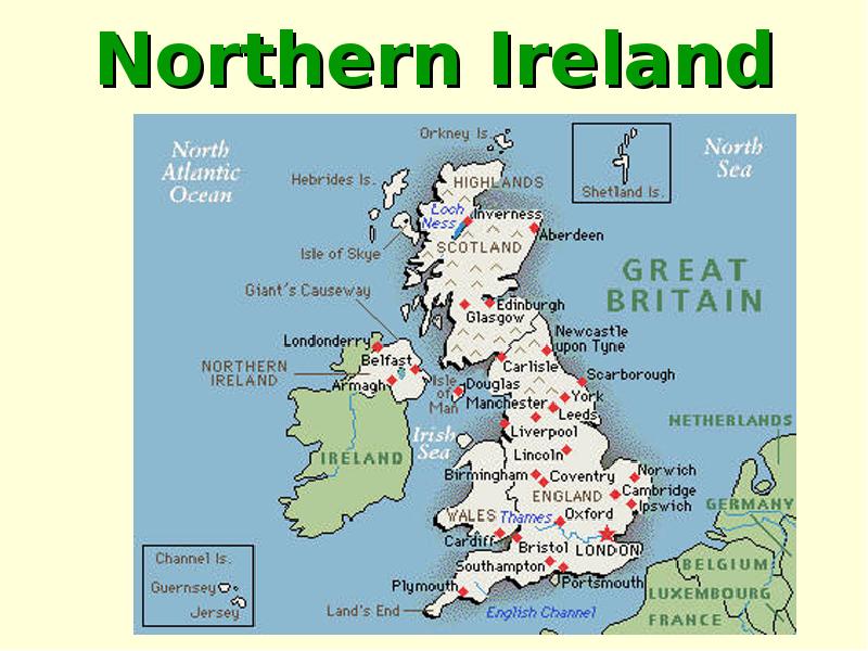
	The British Isles has two islands. The largest island is called Great Britain. The smaller one is called Ireland.The southern part of Ireland is the Republic of Eire. The Northern part is a part of Great Britain. Ireland is separated from Britain by the Irish Sea.
Описание слайда:
Geography The British Isles has two islands. The largest island is called Great Britain. The smaller one is called Ireland.The southern part of Ireland is the Republic of Eire. The Northern part is a part of Great Britain. Ireland is separated from Britain by the Irish Sea.

Слайд 4


	About 15,000 years ago, Ireland was completely covered by thick glaciers.
	About 15,000 years ago, Ireland was completely covered by thick glaciers.
Описание слайда:
About 15,000 years ago, Ireland was completely covered by thick glaciers. About 15,000 years ago, Ireland was completely covered by thick glaciers.

Слайд 5


	Nowadays Ireland is known for its green fields. In fact, its nickname is the Emerald Isle.
	Nowadays Ireland is known for its green fields. In fact, its nickname is the Emerald Isle.
Описание слайда:
Nowadays Ireland is known for its green fields. In fact, its nickname is the Emerald Isle. Nowadays Ireland is known for its green fields. In fact, its nickname is the Emerald Isle.

Слайд 6


	There are mountains on the south-east of the Northern Ireland. Slieve Donard is the highest point in Northern Ireland (850 metres) Belfast's most prominent peak is Cavehill.
	There are mountains on the south-east of the Northern Ireland. Slieve Donard is the highest point in Northern Ireland (850 metres) Belfast's most prominent peak is Cavehill.
Описание слайда:
There are mountains on the south-east of the Northern Ireland. Slieve Donard is the highest point in Northern Ireland (850 metres) Belfast's most prominent peak is Cavehill. There are mountains on the south-east of the Northern Ireland. Slieve Donard is the highest point in Northern Ireland (850 metres) Belfast's most prominent peak is Cavehill.

Слайд 7


	Lough Neagh, is the largest freshwater lake both on the island of Ireland and in the British Isles.
Описание слайда:
Lough Neagh, is the largest freshwater lake both on the island of Ireland and in the British Isles.

Слайд 8


Symbols of Northern Ireland
Описание слайда:
Symbols of Northern Ireland


Теги Northern Ireland
Похожие презентации
Mypresentation.ru
Загрузить презентацию